


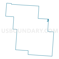
ROSEVILLE Voting District, Perry County, Ohio
About
Outline

Summary
| Unique Area Identifier | 650934 |
| Name | ROSEVILLE Voting District |
| County | Perry County |
| State | Ohio |
| Area (square miles) | 0.35 |
| Land Area (square miles) | 0.34 |
| Water Area (square miles) | 0.00 |
| % of Land Area | 98.87 |
| % of Water Area | 1.13 |
| Latitude of the Internal Point | 39.80761370 |
| Longtitude of the Internal Point | -82.07794200 |
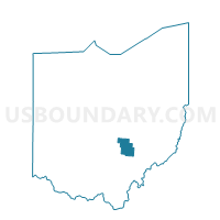
Maps

Graphs
Select a template below for downloading or customizing gragh for ROSEVILLE Voting District, Perry County, Ohio


Neighbors
Neighoring Voting District (by Name) Neighboring Voting District on the Map
- HARRISON Voting District, Perry County, OH
- PRECINCT CLAY, Muskingum County, OH
- PRECINCT IRONSPOT, Muskingum County, OH
Top 10 Neighboring County Subdivision (by Population) Neighboring County Subdivision on the Map
- Newton township, Muskingum County, OH (5,373)
- Harrison township, Perry County, OH (5,253)
- Clay township, Muskingum County, OH (1,078)